
Make a donation
Gear up for your next adventure:
As an Amazon Associate, this site earns from qualifying purchases at no extra cost to you.
Temuco topographic map
Click on the map to display elevation.
Make a donation
Gear up for your next adventure:
As an Amazon Associate, this site earns from qualifying purchases at no extra cost to you.
About this map
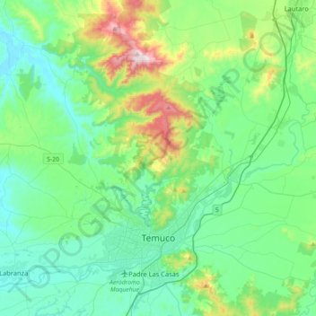
Name: Temuco topographic map, elevation, terrain.
Location: Temuco, Provincia de Cautín, Araucania Region, Chile (-38.78197 -72.82474 -38.54931 -72.46965)
Average elevation: 623 ft
Minimum elevation: 105 ft
Maximum elevation: 2,543 ft
Make a donation
Gear up for your next adventure:
As an Amazon Associate, this site earns from qualifying purchases at no extra cost to you.
Other topographic maps
Click on a map to view its topography, its elevation and its terrain.
Make a donation
Gear up for your next adventure:
As an Amazon Associate, this site earns from qualifying purchases at no extra cost to you.
Volcán Llaima
Chile > Araucanía Region > Provincia de Cautín > Vilcún
The average elevation of the terrain around Llaima is about 740 m asl.
Average elevation: 8,264 ft
Make a donation
Gear up for your next adventure:
As an Amazon Associate, this site earns from qualifying purchases at no extra cost to you.