Geolocate

Lac Robinson topographic map

Click on the map to display elevation.

About this map

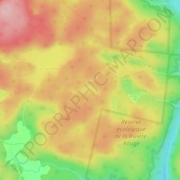
Name: Lac Robinson topographic map, elevation, terrain.

Location: Lac Robinson, Grenville-sur-la-Rouge, Argenteuil, Laurentides, Quebec, Canada (45.68348 -74.68796 45.68515 -74.68186)

Average elevation: 623 ft

Minimum elevation: 299 ft

Maximum elevation: 863 ft

Other topographic maps

Click on a map to view its topography, its elevation and its terrain.

Calumet

Canada > Quebec > Argenteuil > Grenville-sur-la-Rouge

Average elevation: 312 ft

Gear up for your next adventure:

🗺️NatGeo Topo Maps - High-quality waterproof printed topographic maps of US Parks
🩹Survival Bandages - High‑quality bandages for emergencies
🔊Portable Camp Speaker - Music and alerts at camp
🪄Magnetic Compass - Accurate compass for navigation
📡Handheld GPS Device - Reliable handheld GPS for outdoor navigation

As an Amazon Associate, this site earns from qualifying purchases at no extra cost to you.