
Godawari topographic map
Click on the map to display elevation.
About this map
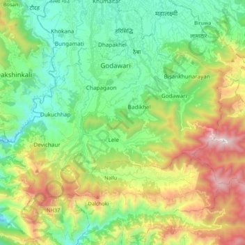
Name: Godawari topographic map, elevation, terrain.
Location: Godawari, Lalitpur, Bagamati Province, Nepal (27.52823 85.24957 27.63450 85.41323)
Average elevation: 5,502 ft
Minimum elevation: 3,793 ft
Maximum elevation: 8,973 ft
Other topographic maps
Click on a map to view its topography, its elevation and its terrain.
Lalitpur
Nepal > Bagamati Province > Lalitpur
Lalitpur (Nepali: ललितपुर [ləˈlɪt̪pʊɾ]), locally known as Yala (Nepal Bhasa: 𑐫𑐮 [jəˈlʌ]) is a metropolitan city and fourth most populous city of Nepal with 299,843 inhabitants living in 77,159 households per the 2021 census. It is located in the south-central part of…
Average elevation: 5,276 ft
Lalitpur
Nepal > Bagamati Province > Lalitpur
Lalitpur Metropolitan City (Sanskrit: पाटन Pāṭana, Nepal bhasa : 𑐫𑐮 Yala) is a metropolitan city and fourth most populous city of Nepal with 299,843 inhabitants living in 49,044 households per the 2021 census. It is located in the south-central part of Kathmandu Valley, a large valley in…
Average elevation: 5,276 ft
Lalitpur
Nepal > Bagamati Province > Lalitpur
Lalitpur (Nepali: ललितपुर) is a metropolitan city and fourth most populous city of Nepal with 299,843 inhabitants living in 77,159 households per the 2021 census. It is located in the south-central part of Kathmandu Valley, a large valley in the high plateaus in central Nepal, at an altitude of…
Average elevation: 5,276 ft
Lalitpur
Nepal > Bagamati Province > Lalitpur
Lalitpur Metropolitan City (Sanskrit: पाटन Pāṭana, Nepal bhasa : 𑐫𑐮 Yela, ) is a Metropolitan city and fourth most populous city of Nepal with 299,843 inhabitants living in 49,044 households per 2021 census. It is located in the south-central part of Kathmandu Valley, a large valley in the…
Average elevation: 5,276 ft
Lalitpur
Nepal > Bagamati Province > Lalitpur
Lalitpur (Nepali: ललितपुर) is a metropolitan city and fourth most populous city of Nepal with 299,843 inhabitants living in 77,159 households per the 2021 census. It is located in the south-central part of Kathmandu Valley, a large valley in the high plateaus in central Nepal, at an altitude of…
Average elevation: 5,276 ft
Lalitpur
Nepal > Bagamati Province > Lalitpur
Lalitpur Metropolitan City (Nepali: ललितपुर महानगरपालिका, Lālitapura Mahānagarapālikā), also known as Patan (Sanskrit: पाटन, Pāṭana), Yala (Newar: 𑐫𑐮), and Manigal, is a metropolitan city and fourth most populous city of Nepal with 299,843 inhabitants…
Average elevation: 5,276 ft