
Make a donation
Gear up for your next adventure:
As an Amazon Associate, this site earns from qualifying purchases at no extra cost to you.
Godawari topographic map
Click on the map to display elevation.
Make a donation
Gear up for your next adventure:
As an Amazon Associate, this site earns from qualifying purchases at no extra cost to you.
About this map
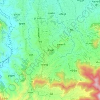
Name: Godawari topographic map, elevation, terrain.
Location: Godawari, Lalitpur, Bagamati Province, 44760, Nepal (27.57563 85.29456 27.65563 85.37456)
Average elevation: 4,672 ft
Minimum elevation: 4,081 ft
Maximum elevation: 6,542 ft
Make a donation
Gear up for your next adventure:
As an Amazon Associate, this site earns from qualifying purchases at no extra cost to you.
Other topographic maps
Click on a map to view its topography, its elevation and its terrain.
Kathmandu Valley
Nepal > Bagamati Province > Lalitpur
Kathmandu Valley is bowl-shaped. Its central lower part stands at 1,425 metres (4,675 ft). Kathmandu Valley is surrounded by five mountain ranges: Shivapuri hills (at an elevation of 2,732 metres (8,963 ft)), Phulchowki (2,762 metres or 9,062 feet), Nagarjun (2,128 metres or 6,982 feet), Champadevi (2,278…
Average elevation: 5,233 ft
Make a donation
Gear up for your next adventure:
As an Amazon Associate, this site earns from qualifying purchases at no extra cost to you.