
Druogno topographic map
Click on the map to display elevation.
About this map
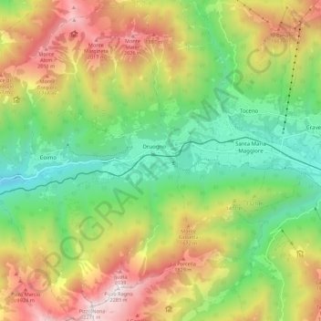
Name: Druogno topographic map, elevation, terrain.
Location: Druogno, Verbano-Cusio-Ossola, Piemonte, Italia (46.09365 8.37495 46.16980 8.44565)
Average elevation: 4,245 ft
Minimum elevation: 2,021 ft
Maximum elevation: 7,411 ft
Other topographic maps
Click on a map to view its topography, its elevation and its terrain.
Alpe Veglia
Italia > Piemonte > Verbano-Cusio-Ossola > Varzo > Alpe Veglia
Average elevation: 6,877 ft
Ruscone
Italia > Piemonte > Verbano-Cusio-Ossola > Beura-Cardezza > Alpe Coriesco
Average elevation: 3,133 ft
Alpe Andolla
Italia > Piemonte > Verbano-Cusio-Ossola > Antrona Schieranco
Average elevation: 7,119 ft
Lago Azzurro (Lago delle Streghe)
Italia > Piemonte > Verbano-Cusio-Ossola > Baceno > Crampiolo
Average elevation: 6,391 ft