Geolocate

Istmina topographic map

Click on the map to display elevation.

Istmina

Istmina is a municipality and town in the Chocó Department, Colombia. The town of Istmina was founded in 1834 by Juan Nepomuceno Mosquera, initially with the name of San Pablo. The name was changed in 1903 to Istmina, a contraction of isthmus and minas (mines), two characteristics of the area. The municipality covers 1,880 square kilometres (726 sq mi), with an average elevation of 79 metres (259 ft), and an average temperature of 26.7 °C (80 °F). Istmina is located 75 km (47 mi) from the departmental capital, Quibdó.

Wikipedia (CC-BY-SA 3.0)

About this map

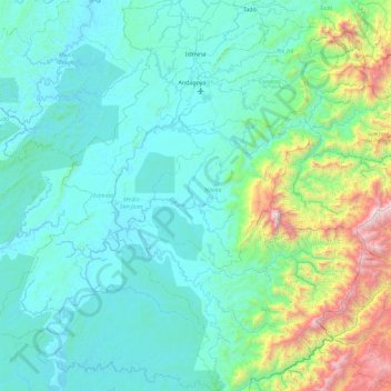
Name: Istmina topographic map, elevation, terrain.

Location: Istmina, San Juan, Chocó, RAP Pacífico, 274010, Colombia (4.37290 -77.16109 5.28498 -76.52495)

Average elevation: 1,250 ft

Minimum elevation: -7 ft

Maximum elevation: 9,006 ft

Other topographic maps

Click on a map to view its topography, its elevation and its terrain.

Salaquí

Colombia > Chocó > Belén de Bajirá

Average elevation: 246 ft

La lomita

Colombia > Chocó > La Italia

Average elevation: 1,929 ft

Río Purricha

Colombia > Chocó > Medio Baudó

Average elevation: 210 ft

Capurganá

Colombia > Chocó > Acandí

Average elevation: 174 ft

Plan De Raspadura

Colombia > Chocó > Las Ánimas

Average elevation: 335 ft

Noanama

Colombia > Chocó > Medio San Juan

Average elevation: 102 ft

Quibdó

Colombia > Chocó > Quibdó > Quibdó

Average elevation: 187 ft

Gear up for your next adventure:

🕶️GPS Smartphone Mount - Secure mount for phone navigation
🔭Telescopic Hiking Pole - Adjustable pole for hiking stability
🛰️Satellite Messengers - Emergency SOS and two-way messaging for off-grid adventures
🧤Tactile Hiking Gloves - Keep hands warm while operating GPS and smartphone screens
🗺️NatGeo Topo Maps - High-quality waterproof printed topographic maps of US Parks

As an Amazon Associate, this site earns from qualifying purchases at no extra cost to you.