Geolocate

Bidur topographic map

Click on the map to display elevation.

About this map

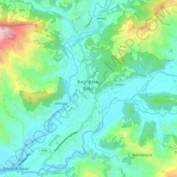
Name: Bidur topographic map, elevation, terrain.

Location: Bidur, Nuwakot, Bagamati Province, 44900, Nepal (27.85526 85.10645 27.93526 85.18645)

Average elevation: 2,274 ft

Minimum elevation: 1,509 ft

Maximum elevation: 5,046 ft

Other topographic maps

Click on a map to view its topography, its elevation and its terrain.

Kispang

Nepal > Bagamati Province > Nuwakot

Average elevation: 6,880 ft

Tarkeshwar

Nepal > Bagamati Province > Nuwakot

Average elevation: 3,235 ft

Shivapuri

Nepal > Bagamati Province > Nuwakot

Average elevation: 4,954 ft

Shivapuri-03

Nepal > Bagamati Province > Nuwakot

Average elevation: 4,409 ft

Kispang

Nepal > Bagamati Province > Nuwakot

Average elevation: 6,880 ft

Gear up for your next adventure:

❄️Traction Cleats - Prevent slips on icy trails during winter hikes
🧤Hiking Gloves - Protective gloves for rugged trails
🔋Rechargeable Batteries - Power up your outdoor devices
🥤Water Filter Bottle - All‑in‑one filter bottle for safe hydration
🎒Hydration Pack - Hands‑free water reservoir for long hikes

As an Amazon Associate, this site earns from qualifying purchases at no extra cost to you.