
Selborne topographic map
Click on the map to display elevation.
About this map
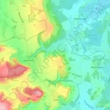
Name: Selborne topographic map, elevation, terrain.
Location: Selborne, East Hampshire, Hampshire, England, United Kingdom (51.07326 -0.96835 51.12757 -0.87892)
Average elevation: 390 ft
Minimum elevation: 233 ft
Maximum elevation: 725 ft
Other topographic maps
Click on a map to view its topography, its elevation and its terrain.
Liphook
United Kingdom > England > Hampshire > East Hampshire
In Samuel Lewis's 1831 Topographical Dictionary of England, he referred to Liphook as a hamlet in the parish of Bramshott.
Average elevation: 397 ft
Rowland's Copse, Red Hill
United Kingdom > England > Hampshire > East Hampshire > Rowlands Castle
Average elevation: 138 ft
Cold Ash Hill
United Kingdom > England > Hampshire > East Hampshire > Bramshott
Average elevation: 413 ft
Hartley Mauditt
United Kingdom > England > Hampshire > East Hampshire > Hartley Mauditt
Average elevation: 404 ft
Comp
United Kingdom > England > Hampshire > East Hampshire > Upper Farringdon
Average elevation: 413 ft
Bramshott Common
United Kingdom > England > Hampshire > East Hampshire > Bramshott
Average elevation: 486 ft
Gilbert Street
United Kingdom > England > Hampshire > East Hampshire > Ropley
Average elevation: 495 ft
Havant Thicket
United Kingdom > England > Hampshire > East Hampshire > Rowlands Castle
Average elevation: 157 ft
Ludshott Common
United Kingdom > England > Hampshire > East Hampshire > Bramshott
Average elevation: 531 ft
Ditcham Woods.
United Kingdom > England > Hampshire > East Hampshire > Buriton
Average elevation: 446 ft
Merryfield
United Kingdom > England > Hampshire > East Hampshire > West Tisted
Average elevation: 538 ft
Neatham
United Kingdom > England > Hampshire > East Hampshire > Alton > Holybourne
Average elevation: 400 ft
Froxfield Green
United Kingdom > England > Hampshire > East Hampshire > High Cross
Average elevation: 581 ft