
Make a donation
Gear up for your next adventure:
As an Amazon Associate, this site earns from qualifying purchases at no extra cost to you.
West Bandung topographic map
Click on the map to display elevation.
Make a donation
Gear up for your next adventure:
As an Amazon Associate, this site earns from qualifying purchases at no extra cost to you.
About this map
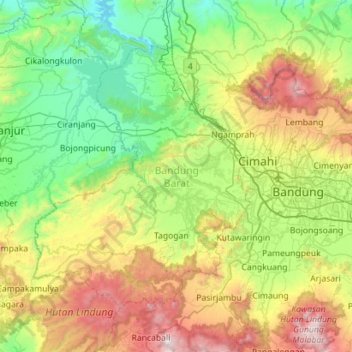
Name: West Bandung topographic map, elevation, terrain.
Location: West Bandung, West Java, Java, Indonesia (-7.10718 107.18194 -6.68851 107.74616)
Average elevation: 2,638 ft
Minimum elevation: 315 ft
Maximum elevation: 7,867 ft
Make a donation
Gear up for your next adventure:
As an Amazon Associate, this site earns from qualifying purchases at no extra cost to you.
Other topographic maps
Click on a map to view its topography, its elevation and its terrain.
Telagabodas
Mount Talagabodas or Mount Telagabodas (which means Mount of White Lake (refer to white crater lake) in Sundanese) is a stratovolcano in West Java, Indonesia. The volcano is about 25 km to the east of the town of Garut and is built up of andesitic lavas and pyroclastics. Fumaroles, mud pots and hot springs are…
Average elevation: 5,692 ft
Make a donation
Gear up for your next adventure:
As an Amazon Associate, this site earns from qualifying purchases at no extra cost to you.
Make a donation
Gear up for your next adventure:
As an Amazon Associate, this site earns from qualifying purchases at no extra cost to you.
Make a donation
Gear up for your next adventure:
As an Amazon Associate, this site earns from qualifying purchases at no extra cost to you.
Bandung
Indonesia > West Java > Bandung
Bandung, the capital of West Java province, located about 180 kilometres (110 mi) southeast of Jakarta, is the third-largest city in Indonesia. Its elevation is 768 metres (2,520 ft) above sea level and is surrounded by up to 2,400 metres (7,900 feet) high Late Tertiary and Quaternary volcanic terrain. The 400…
Average elevation: 2,884 ft