
Make a donation
Gear up for your next adventure:
As an Amazon Associate, this site earns from qualifying purchases at no extra cost to you.
Solingen topographic map
Click on the map to display elevation.
Make a donation
Gear up for your next adventure:
As an Amazon Associate, this site earns from qualifying purchases at no extra cost to you.
Solingen
Das Stadtgebiet Solingens hat eine Größe von 89,54 km². Die größte Ost-West-Ausdehnung beträgt 15,68 Kilometer, die größte Nord-Süd-Ausdehnung 11,7 Kilometer. Der geographische Mittelpunkt der Stadt befindet sich hinter dem Haus Damaschkestraße 17 in Solingen-Mitte. Er wurde offiziell ermittelt und mit einem Felsblock gekennzeichnet. Die Stadtgrenze hat eine Gesamtlänge von 62 Kilometern, wovon die Wupper als Fluss eine natürliche Stadtgrenze von ca. 26 Kilometer bildet. Solingen liegt auf 51 Grad 10 Minuten nördlicher Breite und 7 Grad 3 Minuten östlicher Länge. Auf dem gleichen Breitengrad wie Leipzig, London und Quebec und auf dem gleichen Längengrad wie Monaco und Basel. Der höchste Punkt im Stadtgebiet befindet sich mit 276 Metern über Normalhöhennull am ehemaligen Gräfrather Wasserturm, dem heutigen Lichtturm. Der tiefste Punkt befindet sich in der Ohligser Heide und liegt nur 53 Meter über Normalhöhennull.
Make a donation
Gear up for your next adventure:
As an Amazon Associate, this site earns from qualifying purchases at no extra cost to you.
About this map
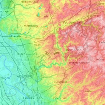
Name: Solingen topographic map, elevation, terrain.
Average elevation: 554 ft
Minimum elevation: 102 ft
Maximum elevation: 1,247 ft
Make a donation
Gear up for your next adventure:
As an Amazon Associate, this site earns from qualifying purchases at no extra cost to you.
Other topographic maps
Click on a map to view its topography, its elevation and its terrain.
Schloss Burg
Deutschland > Nordrhein-Westfalen > Solingen > Oberburg
Schloss Burg (auch Schloss Burg an der Wupper) ist eine ab dem späten 19. Jahrhundert rekonstruierte Höhenburg im Solinger Stadtteil Burg an der Wupper. Die Anlage war seit dem 12. Jahrhundert die Stammburg der Grafen und späteren Herzöge von Berg und ist heute das Wahrzeichen des Bergischen Landes.…
Average elevation: 623 ft
Make a donation
Gear up for your next adventure:
As an Amazon Associate, this site earns from qualifying purchases at no extra cost to you.