
Make a donation
Gear up for your next adventure:
As an Amazon Associate, this site earns from qualifying purchases at no extra cost to you.
Bärenloch topographic map
Click on the map to display elevation.
Make a donation
Gear up for your next adventure:
As an Amazon Associate, this site earns from qualifying purchases at no extra cost to you.
About this map
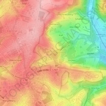
Name: Bärenloch topographic map, elevation, terrain.
Location: Bärenloch, Gräfrath, Solingen, Nordrhein-Westfalen, Deutschland (51.18304 7.08155 51.19116 7.10170)
Average elevation: 673 ft
Minimum elevation: 361 ft
Maximum elevation: 853 ft
Make a donation
Gear up for your next adventure:
As an Amazon Associate, this site earns from qualifying purchases at no extra cost to you.
Other topographic maps
Click on a map to view its topography, its elevation and its terrain.
Solingen
Deutschland > Nordrhein-Westfalen > Solingen
Das Stadtgebiet Solingens hat eine Größe von 89,54 km². Die größte Ost-West-Ausdehnung beträgt 15,68 Kilometer, die größte Nord-Süd-Ausdehnung 11,7 Kilometer. Der geographische Mittelpunkt der Stadt befindet sich hinter dem Haus Damaschkestraße 17 in Solingen-Mitte. Er wurde offiziell ermittelt und…
Average elevation: 554 ft
Make a donation
Gear up for your next adventure:
As an Amazon Associate, this site earns from qualifying purchases at no extra cost to you.
Make a donation
Gear up for your next adventure:
As an Amazon Associate, this site earns from qualifying purchases at no extra cost to you.
Make a donation
Gear up for your next adventure:
As an Amazon Associate, this site earns from qualifying purchases at no extra cost to you.
Make a donation
Gear up for your next adventure:
As an Amazon Associate, this site earns from qualifying purchases at no extra cost to you.
Make a donation
Gear up for your next adventure:
As an Amazon Associate, this site earns from qualifying purchases at no extra cost to you.
Make a donation
Gear up for your next adventure:
As an Amazon Associate, this site earns from qualifying purchases at no extra cost to you.
Hintenmeiswinkel
Deutschland > Nordrhein-Westfalen > Solingen > Hintenmeiswinkel
Average elevation: 446 ft
Make a donation
Gear up for your next adventure:
As an Amazon Associate, this site earns from qualifying purchases at no extra cost to you.
Obenmankhaus
Deutschland > Nordrhein-Westfalen > Solingen
Obenmankhaus befindet sich im Grenzgebiet zwischen den beiden Stadtteilen Merscheid und Ohligs auf einem Höhenrücken im Norden des Viehbachtals. Der Ort liegt in einem Wohngebiet südlich der Merscheider Straße und der dort befindlichen Cobra, dort an der Brunnenstraße, die in den Mankhauser Pött führt…
Average elevation: 433 ft
Make a donation
Gear up for your next adventure:
As an Amazon Associate, this site earns from qualifying purchases at no extra cost to you.