
Habergham Eaves topographic map
Interactive map
Click on the map to display elevation.
About this map
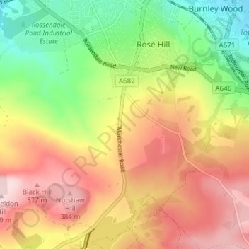
Name: Habergham Eaves topographic map, elevation, terrain.
Location: Habergham Eaves, Burnley, Lancashire, England, United Kingdom (53.74904 -2.28771 53.78207 -2.22554)
Average elevation: 860 ft
Minimum elevation: 397 ft
Maximum elevation: 1,312 ft
Other topographic maps
Click on a map to view its topography, its elevation and its terrain.
Haggate
United Kingdom > England > Lancashire > Burnley
Haggate, Burnley, Lancashire, England, BB10 3QH, United Kingdom
Average elevation: 722 ft
Padiham
United Kingdom > England > Lancashire > Burnley
Padiham, Burnley, Lancashire, England, United Kingdom
Average elevation: 341 ft