
Wilmslow topographic map
Click on the map to display elevation.
About this map
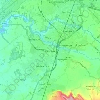
Name: Wilmslow topographic map, elevation, terrain.
Location: Wilmslow, Cheshire East, England, United Kingdom (53.30563 -2.28793 53.34786 -2.18470)
Average elevation: 266 ft
Minimum elevation: 141 ft
Maximum elevation: 630 ft
Other topographic maps
Click on a map to view its topography, its elevation and its terrain.
Bickerton Hill
United Kingdom > England > Cheshire East > Bickerton
Bickerton Hill refers to two low red sandstone hills that form the southern end of the Mid Cheshire Ridge in Cheshire, north-west England. The high point, Raw Head, lies on the northerly hill and has an elevation of 227 metres. Parts of the southerly hill are also known as Larkton Hill.
Average elevation: 440 ft