Geolocate

Ashley topographic map

Click on the map to display elevation.

About this map

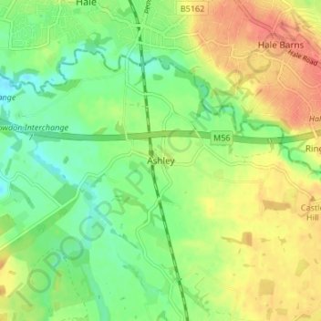
Name: Ashley topographic map, elevation, terrain.

Location: Ashley, Cheshire East, England, WA15 0QR, United Kingdom (53.33472 -2.35942 53.37472 -2.31942)

Average elevation: 144 ft

Minimum elevation: 66 ft

Maximum elevation: 233 ft

Other topographic maps

Click on a map to view its topography, its elevation and its terrain.

Wilmslow

United Kingdom > England > Cheshire East

Average elevation: 266 ft

Audlem

United Kingdom > England > Cheshire East

Average elevation: 236 ft

Nether Alderley

United Kingdom > England > Cheshire East

Average elevation: 322 ft

Norbury

United Kingdom > England > Cheshire East

Average elevation: 269 ft

Smallwood

United Kingdom > England > Cheshire East

Average elevation: 282 ft

Alderley Edge

United Kingdom > England > Cheshire East > Alderley Edge

Alderley Edge is 6 miles (10 km) northwest of Macclesfield and 12 miles (19 km) south of Manchester, at the base of a steep and thickly wooded sandstone escarpment, Alderley Edge, which is the area's chief topographical feature and overlooks the Cheshire Plain.

Average elevation: 299 ft

Nantwich

United Kingdom > England > Cheshire East

Average elevation: 148 ft

Knutsford

United Kingdom > England > Cheshire East

Average elevation: 190 ft

Walgherton

United Kingdom > England > Cheshire East > Wybunbury > Walgherton

Average elevation: 207 ft

Disley

United Kingdom > England > Cheshire East

Average elevation: 751 ft

Chorley

United Kingdom > England > Cheshire East > Chorley

Average elevation: 240 ft

Church Minshull

United Kingdom > England > Cheshire East

Average elevation: 148 ft

Cholmondeston

United Kingdom > England > Cheshire East

The civil parish has a total area of 1,749 acres (708 ha).[17] The terrain is predominantly flat, with an average elevation of around 50 metres. A trig point is located at SJ631567, at an elevation of 55 metres. Crowton Brook runs north–south through the civil parish and Bankside Brook forms part of the…

Average elevation: 157 ft

Gear up for your next adventure:

🏕️Tent Footprint - Protect your tent base from wear
🧥Waterproof Jacket for Hiking - Breathable and rugged rain jacket for outdoor excursions
🩳Quick‑Dry Hiking Shorts - Comfortable and quick‑dry shorts for summer hiking
🎒Hydration Pack - Hands‑free water reservoir for long hikes
🔥Plasma Lighters - Windproof lighters that work in any weather condition

As an Amazon Associate, this site earns from qualifying purchases at no extra cost to you.