Geolocate

Morrison topographic map

Click on the map to display elevation.

About this map

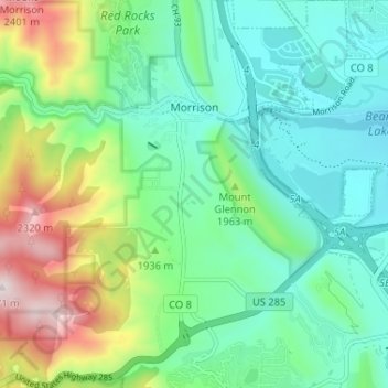
Name: Morrison topographic map, elevation, terrain.

Location: Morrison, Jefferson County, Colorado, 80465, United States (39.61748 -105.22206 39.66738 -105.16243)

Average elevation: 6,207 ft

Minimum elevation: 5,604 ft

Maximum elevation: 7,733 ft

Jefferson County trails, hiking, mountain biking, running and outdoor activities

Other topographic maps

Click on a map to view its topography, its elevation and its terrain.

Genesee

United States > Colorado > Jefferson County

Average elevation: 7,379 ft

Hiwan Hills

United States > Colorado > Jefferson County > Evergreen

Average elevation: 7,346 ft

Red Rocks Park

United States > Colorado > Jefferson County > Golden

Average elevation: 6,296 ft

Evergreen

United States > Colorado > Jefferson County

Evergreen sits at an elevation of 7,220 feet (2,200 m) in the Rocky Mountains, 19 miles west of Denver, Colorado.

Average elevation: 7,549 ft

Edgewater

United States > Colorado > Jefferson County

Average elevation: 5,397 ft

Aspen Park

United States > Colorado > Jefferson County

Average elevation: 8,235 ft

Stanley Park

United States > Colorado > Jefferson County > Evergreen

Average elevation: 7,762 ft

Mountain View

United States > Colorado > Jefferson County

Average elevation: 5,400 ft

Lakeside

United States > Colorado > Jefferson County

Average elevation: 5,371 ft

Golden

United States > Colorado > Jefferson County > Golden > Golden

Average elevation: 6,640 ft

Lookout Mountain

United States > Colorado > Jefferson County

Average elevation: 6,900 ft

Brook Forest

United States > Colorado > Jefferson County

Average elevation: 8,448 ft

Cheesman Lake

United States > Colorado > Jefferson County

Average elevation: 7,287 ft

Plainview

United States > Colorado > Jefferson County > Plainview

Average elevation: 6,850 ft

Apex Park

United States > Colorado > Jefferson County > Golden

Average elevation: 6,663 ft

Windy Saddle Park

United States > Colorado > Jefferson County > Golden

Average elevation: 6,552 ft

Deermont

United States > Colorado > Jefferson County

Average elevation: 7,457 ft

Silver Cliff

United States > Colorado > Jefferson County

Average elevation: 6,988 ft

Gear up for your next adventure:

🛏️Cold Weather Sleeping Bag - Warm sleeping bag for cold conditions
🪶Compact Camp Shovel - Folding shovel for campsite tasks
🪓Survival Multi‑Tool - Versatile tool for camp and trail tasks
🪶Trail Camera - Capture wildlife on your hikes
🦶Hiking Gaiters - Keep debris and water out of your boots

As an Amazon Associate, this site earns from qualifying purchases at no extra cost to you.