
Evergreen topographic map
Click on the map to display elevation.
Evergreen
Evergreen sits at an elevation of 7,220 feet (2,200 m) in the Rocky Mountains, 19 miles west of Denver, Colorado.
About this map
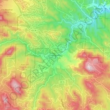
Name: Evergreen topographic map, elevation, terrain.
Average elevation: 7,549 ft
Minimum elevation: 6,650 ft
Maximum elevation: 8,599 ft
Jefferson County trails, hiking, mountain biking, running and outdoor activities
Other topographic maps
Click on a map to view its topography, its elevation and its terrain.
Lakewood
United States > Colorado > Jefferson County > Lakewood
Lakewood is located at 39°42′17″N 105°04′53″W / 39.70472°N 105.08139°W / 39.70472; -105.08139 at an elevation of 5,518 feet (1,682 m). Located at the junction of U.S. Route 6 and Colorado State Highway 121 in central Colorado, the city lies immediately west of Denver and 62 miles (100 km)…
Average elevation: 5,633 ft
Bear Creek Lake Park
United States > Colorado > Jefferson County > Lakewood
Average elevation: 5,712 ft
Alderfer/Three Sisters Park
United States > Colorado > Jefferson County > Evergreen
Average elevation: 7,602 ft