Geolocate

Panitan topographic map

Click on the map to display elevation.

About this map

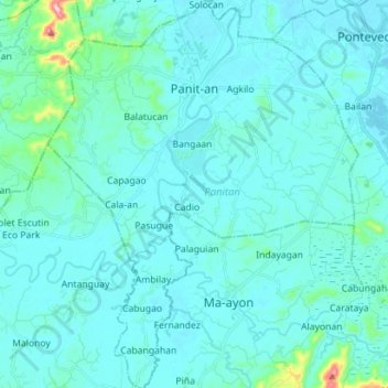
Name: Panitan topographic map, elevation, terrain.

Location: Panitan, Capiz, Western Visayas, 5815, Philippines (11.35624 122.71534 11.49454 122.82835)

Average elevation: 89 ft

Minimum elevation: -3 ft

Maximum elevation: 994 ft

Other topographic maps

Click on a map to view its topography, its elevation and its terrain.

Nagba

Philippines > Capiz > Cuartero

Average elevation: 75 ft

Roxas

Philippines > Capiz

Average elevation: 33 ft

Timpas

Philippines > Capiz > Panitan

Average elevation: 246 ft

Mount Carabao

Philippines > Capiz > Jamindan

Average elevation: 1,309 ft

Panay River

Philippines > Capiz > Roxas City > Loctugan

Average elevation: 33 ft

Gear up for your next adventure:

👟Trail Running Shoes - Lightweight shoes for trail runners
Backpacking Tents - Weight-optimized shelters for multi-day topographic surveys
🎒Waterproof Dry Bags - Keep your electronics and maps dry inside your pack
🏔️Mountain Trail Maps - High‑detail maps for popular peaks
🎒Trekking Poles - Sturdy poles for balance and stability on rough terrain

As an Amazon Associate, this site earns from qualifying purchases at no extra cost to you.