
Mount Begbie topographic map
Click on the map to display elevation.
About this map
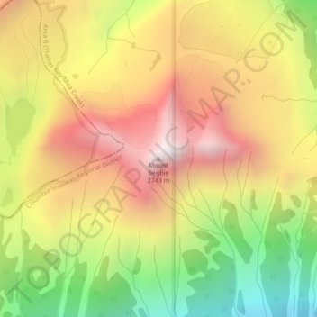
Name: Mount Begbie topographic map, elevation, terrain.
Average elevation: 6,778 ft
Minimum elevation: 4,311 ft
Maximum elevation: 8,953 ft
Other topographic maps
Click on a map to view its topography, its elevation and its terrain.
Upper Arrow Lake
Canada > British Columbia > Columbia-Shuswap Regional District > Area B (Shelter Bay/Mica Creek)
Average elevation: 4,797 ft
Revy Riders Moto Trails Recreation Site
Canada > British Columbia > Columbia-Shuswap Regional District > Area B (Shelter Bay/Mica Creek)
Average elevation: 3,970 ft
Galena Bay
Canada > British Columbia > Columbia-Shuswap Regional District > Area B (Shelter Bay/Mica Creek)
Average elevation: 1,604 ft
Illecillewaet Glacier
Canada > British Columbia > Columbia-Shuswap Regional District > Area B (Shelter Bay/Mica Creek)
Average elevation: 7,917 ft
Asulkan Glacier
Canada > British Columbia > Columbia-Shuswap Regional District > Area B (Shelter Bay/Mica Creek)
Average elevation: 7,559 ft
Bonney Glacier
Canada > British Columbia > Columbia-Shuswap Regional District > Area B (Shelter Bay/Mica Creek)
Average elevation: 7,530 ft
Bear Glacier
Canada > British Columbia > Columbia-Shuswap Regional District > Area B (Shelter Bay/Mica Creek)
Average elevation: 7,434 ft
Mount Revelstoke National Park
Canada > British Columbia > Columbia-Shuswap Regional District > Area B (Shelter Bay/Mica Creek)
Average elevation: 4,846 ft