
Batu topographic map
Click on the map to display elevation.
Batu
In the 19th century, the Dutch East Indies government developed Batu as a mountain resort. Villas and resort facilities were built in Batu during the period. Most of the topography of Batu City is dominated by highland and hilly terrain with valleys running down mountain slopes. In northern Batu, there is a dense forest, Raden Soerjo Forest Park, which is a protected forest area.
About this map
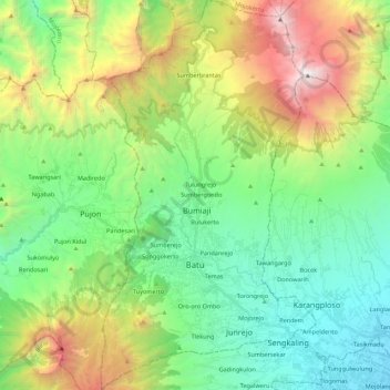
Name: Batu topographic map, elevation, terrain.
Location: Batu, Klojen, Java, Indonesia (-7.94107 112.47393 -7.72388 112.59499)
Average elevation: 4,478 ft
Minimum elevation: 1,572 ft
Maximum elevation: 10,853 ft
Other topographic maps
Click on a map to view its topography, its elevation and its terrain.
Mount Bromo
Indonesia > East Java > Pasuruan
Further eruptions and the issuing of aviation ash advisories during the period 27–28 January 2011 led to concerns being raised regarding a volcanic ash plume, reported to be drifting eastward toward the air corridors used to access the Ngurah Rai International Airport IATA:DPS in Bali. Airport official…
Average elevation: 7,346 ft
King Kong Hill
Indonesia > East Java > Probolinggo > Cemorolawang > Kedaluh
Average elevation: 7,815 ft
Bukit Klangon
Indonesia > Special Region of Yogyakarta > Sleman Regency > Pakem
Average elevation: 4,432 ft
Rinjani
Indonesia > West Nusa Tenggara
Mount Rinjani (Indonesian: Gunung Rinjani; Sasak: ᬕᬸᬦ᭄ᬗᬸᬂ᭞ᬭᬶᬦ᭄ᬚᬦᬶ, romanized: gunong rinjani) is an active stratovolcano situated in regencial North Lombok of West Nusa Tenggara province on the Indonesian island of Lombok. It reaches an elevation of 3,726 metres (12,224 ft),…
Average elevation: 10,075 ft
Bekasi
The City of Bekasi is a part of the Bekasi river basin, located in the downstream area of the basin with slopes ranging from 0 to 2% and elevations between 11 meters to 81 meters above sea level. The city of Bekasi is part of the Bekasi river basin and is located in the downstream area of the basin, with a…
Average elevation: 75 ft
Bukit Bintang
Indonesia > Special Region of Yogyakarta > Gunungkidul Regency > Patuk > Patuk > Ngasemayu
Average elevation: 659 ft
Bojonggenteng
Indonesia > West Java > Bogor > Parung Panjang > Gintung Cilejet
Average elevation: 161 ft
Atambua
Indonesia > East Nusa Tenggara > Belu
The town stretches 8.5 km from north to south and 5 km from east to west, and is in the north of the western half of Timor Island. The town is located at an altitude of about 350 m above sea level with temperatures ranging between 23 and 35 degrees Celsius.
Average elevation: 1,201 ft