
Bali topographic map
Click on the map to display elevation.
About this map
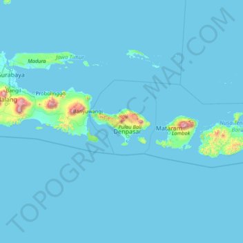
Name: Bali topographic map, elevation, terrain.
Location: Bali, Indonesia (-10.89050 112.53064 -5.77050 117.65064)
Average elevation: 157 ft
Minimum elevation: -3 ft
Maximum elevation: 11,138 ft
Other topographic maps
Click on a map to view its topography, its elevation and its terrain.
Pulau Bali
Bali features a diverse topography shaped by a volcanic origin, which significantly influences its landscapes and climate. The island is dominated by a central mountain range that runs from west to east, with Mount Agung, reaching an elevation of approximately 10,308 feet, standing as the highest peak and a…
Average elevation: 400 ft
Nusa Lembongan
Indonesia > Bali > Klungkung Regency > Jungutbatu > Jungut Batu
Average elevation: 43 ft
Tabanan
The topography of this regency is located between an altitude of 0 - 2,276 meters above sea level, with details; at an altitude of 0 – 500 meters above sea level is a flat area with a slope of 2 - 15%. Meanwhile, at an altitude of 500-1,000 meters above sea level, it is a flat to sloping area with a slope of…
Average elevation: 1,352 ft
Pulau Bali
Bali's central mountains include several peaks over 2,000 metres (6,600 feet) in elevation and active volcanoes such as Mount Batur. The highest is Mount Agung (3,031 m, 9,944 ft), known as the "mother mountain", which is an active volcano rated as one of the world's most likely sites for a massive eruption…
Average elevation: 400 ft
Denpasar
Denpasar is located at an elevation of 4 m (13 ft) above sea level. While the total area of 127.78 km2 or 2.18% of the total area of Bali Province. From the use of land, 2,768 hectares of land are paddy, 10,001 hectares are dry land, while the remaining land area is 9 hectares.
Average elevation: 79 ft
Pecatu
Indonesia > Bali > Kuta Selatan
Pecatu is located in South Kuta District of Badung Regency. It is at the western end of the Bukit Peninsula in south Bali, and has a hilly topography with limestone cliffs isolating small, short beaches that have been privately developed. Nusa Dua, on the opposite side of the peninsula, is flat and is a…
Average elevation: 210 ft
Penida Island
Indonesia > Bali > Nusa Penida
Nusa Penida (Balinese: ᬦᬸᬲᬧᭂᬦᬶᬤ, romanized: Nusa Penida, lit. 'Penida Island') is an island located near the southeastern Indonesian island of Bali and a district of Klungkung Regency that includes the neighbouring small island of Nusa Lembongan and twelve even smaller islands. The Badung…
Average elevation: 341 ft
Penida Island
Indonesia > Bali > Klungkung Regency > Batukandik
Nusa Penida (Balinese: ᬦᬸᬲᬧᭂᬦᬶᬤ, romanized: Nusa Penida, lit. 'Penida Island') is an island located near the southeastern Indonesian island of Bali and a district of Klungkung Regency that includes the neighbouring small island of Nusa Lembongan and twelve even smaller islands. The Badung…
Average elevation: 341 ft
Pecatu
Indonesia > Bali > Kuta Selatan
Pecatu is located in South Kuta District of Badung Regency. It is at the western end of the Bukit Peninsula in south Bali, and has a hilly topography with limestone cliffs isolating small, short beaches that have been privately developed. Nusa Dua, on the opposite side of the peninsula, is flat and is a…
Average elevation: 210 ft
Kelingking Beach
Indonesia > Bali > Klungkung Regency > Bunga Mekar > Karangdewa
Average elevation: 249 ft
Denpasar
Denpasar is located at an elevation of 4 m (13 ft) above sea level. While the total area of 125.98 km2 or 2.18% of the total area of Bali Province. From the use of land, 2,768 hectares of land are paddy, 10,001 hectares are dry land, while the remaining land area is 9 hectares.
Average elevation: 23 ft
Tabanan
Jatiluwih village in Penebel District, north of Tabanan, has paddy fields following the contours of terraced land against the background of spellbinding Mount Batukaru and Mount Agung use traditional Balinese irrigation known as subak, Bali's community-based water control management system. Lies at an altitude…
Average elevation: 1,352 ft
Tabanan
Jatiluwih village in Penebel District, north of Tabanan, has paddy fields following the contours of terraced land against the background of spellbinding Mount Batukaru and Mount Agung use traditional Balinese irrigation known as subak, Bali's community-based water control management system. Lies at an altitude…
Average elevation: 719 ft
CitraLand Waterpark Denpasar
Indonesia > Bali > Denpasar > Denpasar Barat > Padangsambian Kaja
Average elevation: 184 ft
Pecatu
Pecatu is located in South Kuta District of the Badung Regency. It is at the western end of the Bukit Peninsula in south Bali, and has a hilly topography with limestone cliffs isolating small, short beaches that have been privately developed. Nusa Dua, on the opposite side of the peninsula, is flat and is a…
Average elevation: 213 ft
Klungkung Regency
Topographically, the Klungkung Regency area has a variety of land surface heights. Based on its height, the Klungkung Regency area is dominated by hilly areas with an altitude of between 100–500 meters above sea level with an area of 227.48 km2 (87.83 sq mi) or 72.22% of the total area of Klungkung Regency,…
Average elevation: 180 ft
Tabanan
Jatiluwih is an administrative village in Penebel District, north of Tabanan; it is formed with two customary villages, Gunung Sari and Jatiluwih; under these two customary villages there are seven customary hamlets or banjar. The village is at an altitude of 700 meters. Two routes to Jatiluwih are Denpasar >…
Average elevation: 719 ft
Buleleng
Buleleng Regency, located in the north of Bali Island, has a very diverse topography, consisting of lowlands, hills, and mountains. Most of the Buleleng Regency area is a hilly and mountainous area stretching in the south, while in the north, namely along the coast, is a lowland. These unique conditions make…
Average elevation: 325 ft