
Make a donation
Gear up for your next adventure:
As an Amazon Associate, this site earns from qualifying purchases at no extra cost to you.
Koekelare topographic map
Click on the map to display elevation.
Make a donation
Gear up for your next adventure:
As an Amazon Associate, this site earns from qualifying purchases at no extra cost to you.
Koekelare
Koekelare ligt in Zandlemig Vlaanderen. De kom ligt op een hoogte van ongeveer 15 meter, maar de hoogte in de omgeving varieert van 5-47 meter. De hoogste delen vindt men in het zuidoosten, waar zich de steilrand naar het Plateau van Wijnendale bevindt. Daar ligt de Koekelareberg, welke ongeveer 47 meter hoog is. Een aantal beken (Kolvebeek en Plaatsebeek) wateren in zuidwestelijke richting af op de Handzamevaart.
Make a donation
Gear up for your next adventure:
As an Amazon Associate, this site earns from qualifying purchases at no extra cost to you.
About this map
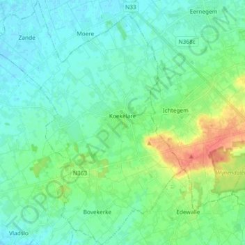
Name: Koekelare topographic map, elevation, terrain.
Location: Koekelare, Diksmuide, West-Vlaanderen, 8680, België (51.04186 2.89934 51.13375 3.01453)
Average elevation: 43 ft
Minimum elevation: -3 ft
Maximum elevation: 177 ft
Make a donation
Gear up for your next adventure:
As an Amazon Associate, this site earns from qualifying purchases at no extra cost to you.
Other topographic maps
Click on a map to view its topography, its elevation and its terrain.
Make a donation
Gear up for your next adventure:
As an Amazon Associate, this site earns from qualifying purchases at no extra cost to you.