Geolocate

Chichijima topographic map

Click on the map to display elevation.

About this map

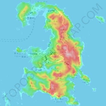
Name: Chichijima topographic map, elevation, terrain.

Location: Chichijima, Tokyo, Japan (27.03572 142.18140 27.10607 142.23790)

Average elevation: 148 ft

Minimum elevation: -7 ft

Maximum elevation: 1,053 ft

Other topographic maps

Click on a map to view its topography, its elevation and its terrain.

Mount Takao

Japan > Tokyo

Average elevation: 1,309 ft

Iō Island

Japan > Tokyo

Average elevation: 89 ft

Mount Takao

Japan > Tokyo

Average elevation: 1,309 ft

Iō Island

Japan > Tokyo

Average elevation: 89 ft

Iō Island

Japan > Tokyo

Average elevation: 89 ft

Tokyo International Airport

Japan > Tokyo

Average elevation: 7 ft

Mount Atago

Japan > Tokyo

Average elevation: 197 ft

Mount Nokogiri

Japan > Tokyo

Average elevation: 2,743 ft

Gear up for your next adventure:

🌄Hiking Binoculars - Compact binoculars for scenic views and trail spotting
🧤Tactile Hiking Gloves - Keep hands warm while operating GPS and smartphone screens
🪶Wildlife Field Guides - Learn animal tracking and species ID
🧭Hiking Compass - Precision compass for reliable navigation in the wilderness
🪶Paracord Bracelet - Survival bracelet with built‑in tools

As an Amazon Associate, this site earns from qualifying purchases at no extra cost to you.