Geolocate

Općina Konavle topographic map

Click on the map to display elevation.

Općina Konavle

The Sniježnica peak at 1234 meters of altitude is the highest point of the Dubrovnik-Neretva County and village of Kuna with its 700 m altitude is the highest village in the county. Although Gruda is the administrative center of the municipality, the largest settlement is Cavtat.

Wikipedia (CC-BY-SA 3.0)

About this map

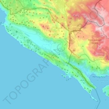
Name: Općina Konavle topographic map, elevation, terrain.

Location: Općina Konavle, Dubrovnik-Neretva County, Croatia (42.39218 18.17394 42.61930 18.53380)

Average elevation: 1,234 ft

Minimum elevation: -3 ft

Maximum elevation: 6,145 ft

Other topographic maps

Click on a map to view its topography, its elevation and its terrain.

Rt Lumpar

Croatia > Dubrovnik-Neretva County > Dubrovnik

Average elevation: 30 ft

Krst

Croatia > Dubrovnik-Neretva County > Dubrovnik

Average elevation: 846 ft

Šibenik

Croatia > Dubrovnik-Neretva County > Duba

Average elevation: 289 ft

Gear up for your next adventure:

🪶Multi‑Purpose Knife - Useful blade for camp and trail
🏥Hiking First Aid Kits - Comprehensive medical kits for remote trail injuries
🧼Biodegradable Camping Soap - Eco‑friendly soap for outdoor hygiene
📱Solar Portable Charger - Solar power bank for charging devices off‑grid
🧦Hiking Socks - Comfortable socks to prevent blisters on long hikes

As an Amazon Associate, this site earns from qualifying purchases at no extra cost to you.