Geolocate

Wolf Run topographic map

Click on the map to display elevation.

About this map

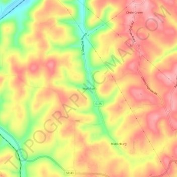
Name: Wolf Run topographic map, elevation, terrain.

Location: Wolf Run, Jefferson County, Ohio, 43970, United States (40.44729 -80.90925 40.48729 -80.86925)

Average elevation: 1,178 ft

Minimum elevation: 899 ft

Maximum elevation: 1,345 ft

Jefferson County trails, hiking, mountain biking, running and outdoor activities

Other topographic maps

Click on a map to view its topography, its elevation and its terrain.

Tiltonsville

United States > Ohio > Jefferson County

Average elevation: 823 ft

Toronto

United States > Ohio > Jefferson County

Average elevation: 909 ft

Adena

United States > Ohio > Jefferson County

Average elevation: 1,017 ft

Richmond

United States > Ohio > Jefferson County

Average elevation: 1,194 ft

Wintersville

United States > Ohio > Jefferson County

Average elevation: 1,135 ft

Irondale

United States > Ohio > Jefferson County > Irondale

Average elevation: 1,010 ft

Bloomingdale

United States > Ohio > Jefferson County

Average elevation: 1,171 ft

Gear up for your next adventure:

🧥Men's Rain Shells - Premium waterproof and breathable jackets for mountain weather
🦶Hiking Gaiters - Keep debris and water out of your boots
🪶Paracord Bracelet - Survival bracelet with built‑in tools
🌎3D Topographic Globes - Raised relief globes for a tactile understanding of geography
🌄Hiking Binoculars - Compact binoculars for scenic views and trail spotting

As an Amazon Associate, this site earns from qualifying purchases at no extra cost to you.