
Make a donation
Gear up for your next adventure:
As an Amazon Associate, this site earns from qualifying purchases at no extra cost to you.
Yarker topographic map
Click on the map to display elevation.
Make a donation
Gear up for your next adventure:
As an Amazon Associate, this site earns from qualifying purchases at no extra cost to you.
About this map
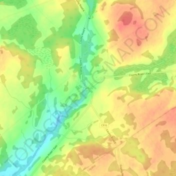
Name: Yarker topographic map, elevation, terrain.
Average elevation: 499 ft
Minimum elevation: 390 ft
Maximum elevation: 574 ft
Make a donation
Gear up for your next adventure:
As an Amazon Associate, this site earns from qualifying purchases at no extra cost to you.
Other topographic maps
Click on a map to view its topography, its elevation and its terrain.
Puzzle Lake Provincial Park
Canada > Ontario > Lennox and Addington County > Stone Mills
Average elevation: 643 ft
Lions Beaver Lake Park
Canada > Ontario > Lennox and Addington County > Stone Mills > Erinsville
Average elevation: 564 ft
Make a donation
Gear up for your next adventure:
As an Amazon Associate, this site earns from qualifying purchases at no extra cost to you.