
Town of Pittsboro topographic map
Interactive map
Click on the map to display elevation.
About this map
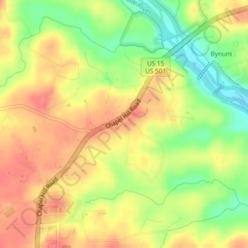
Name: Town of Pittsboro topographic map, elevation, terrain.
Average elevation: 404 ft
Minimum elevation: 285 ft
Maximum elevation: 489 ft
Other topographic maps
Click on a map to view its topography, its elevation and its terrain.
Jordan Lake
United States > North Carolina > Chatham County
Jordan Lake, Chatham County, North Carolina, United States
Average elevation: 335 ft
Moncure
United States > North Carolina > Chatham County
Moncure, Chatham County, North Carolina, 27559, United States
Average elevation: 223 ft
Bonlee
United States > North Carolina > Chatham County
Bonlee, Chatham County, North Carolina, 27213, United States
Average elevation: 509 ft
Pittsboro
United States > North Carolina > Chatham County
Pittsboro, Chatham County, North Carolina, United States
Average elevation: 443 ft
Siler City
United States > North Carolina > Chatham County
Siler City, Chatham County, North Carolina, 27344, United States
Average elevation: 617 ft
Red Hill
United States > North Carolina > Chatham County
Red Hill, Chatham County, North Carolina, United States
Average elevation: 479 ft
Fearrington Village
United States > North Carolina > Chatham County
Fearrington Village, Chatham County, North Carolina, United States
Average elevation: 433 ft