
Make a donation
Gear up for your next adventure:
As an Amazon Associate, this site earns from qualifying purchases at no extra cost to you.
Jordan Lake topographic map
Click on the map to display elevation.
Make a donation
Gear up for your next adventure:
As an Amazon Associate, this site earns from qualifying purchases at no extra cost to you.
Jordan Lake
The Jordan Lake Dam (also known as the B. Everett Jordan Project and the New Hope Dam) is located at 35°39′15″N 79°4′0″W / 35.65417°N 79.06667°W / 35.65417; -79.06667 (B. Everett Jordan Dam) 4 miles (6.4 km) upstream from the mouth of the Haw River in the upper Cape Fear River drainage basin. Completed in 1974 by the Nello L. Teer Company, it is 1,330 feet (410 m) in length and has a top elevation of 266.5 feet (81.2 m) above mean sea level.
Make a donation
Gear up for your next adventure:
As an Amazon Associate, this site earns from qualifying purchases at no extra cost to you.
About this map
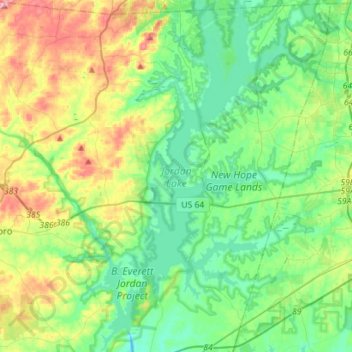
Name: Jordan Lake topographic map, elevation, terrain.
Location: Jordan Lake, Chatham County, North Carolina, United States (35.64128 -79.10467 35.86993 -78.94848)
Average elevation: 335 ft
Minimum elevation: 171 ft
Maximum elevation: 732 ft
Chatham County trails, hiking, mountain biking, running and outdoor activities
Make a donation
Gear up for your next adventure:
As an Amazon Associate, this site earns from qualifying purchases at no extra cost to you.
Other topographic maps
Click on a map to view its topography, its elevation and its terrain.
Governors Club
United States > North Carolina > Chatham County > Governors Club
Average elevation: 351 ft
Make a donation
Gear up for your next adventure:
As an Amazon Associate, this site earns from qualifying purchases at no extra cost to you.
Town of Pittsboro
United States > North Carolina > Chatham County > Town of Pittsboro
Average elevation: 404 ft
Make a donation
Gear up for your next adventure:
As an Amazon Associate, this site earns from qualifying purchases at no extra cost to you.