
Make a donation
Gear up for your next adventure:
As an Amazon Associate, this site earns from qualifying purchases at no extra cost to you.
Moncure topographic map
Click on the map to display elevation.
Make a donation
Gear up for your next adventure:
As an Amazon Associate, this site earns from qualifying purchases at no extra cost to you.
About this map
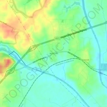
Name: Moncure topographic map, elevation, terrain.
Average elevation: 223 ft
Minimum elevation: 154 ft
Maximum elevation: 341 ft
Chatham County trails, hiking, mountain biking, running and outdoor activities
Make a donation
Gear up for your next adventure:
As an Amazon Associate, this site earns from qualifying purchases at no extra cost to you.
Other topographic maps
Click on a map to view its topography, its elevation and its terrain.
Jordan Lake
United States > North Carolina > Chatham County
The Jordan Lake Dam (also known as the B. Everett Jordan Project and the New Hope Dam) is located at 35°39′15″N 79°4′0″W / 35.65417°N 79.06667°W / 35.65417; -79.06667 (B. Everett Jordan Dam) 4 miles (6.4 km) upstream from the mouth of the Haw River in the upper Cape Fear River drainage…
Average elevation: 335 ft
Make a donation
Gear up for your next adventure:
As an Amazon Associate, this site earns from qualifying purchases at no extra cost to you.
Town of Pittsboro
United States > North Carolina > Chatham County > Town of Pittsboro
Average elevation: 404 ft
Fearrington Village
United States > North Carolina > Chatham County > Fearrington
Average elevation: 417 ft
Make a donation
Gear up for your next adventure:
As an Amazon Associate, this site earns from qualifying purchases at no extra cost to you.