
Make a donation
Gear up for your next adventure:
As an Amazon Associate, this site earns from qualifying purchases at no extra cost to you.
Windheim topographic map
Click on the map to display elevation.
Make a donation
Gear up for your next adventure:
As an Amazon Associate, this site earns from qualifying purchases at no extra cost to you.
About this map
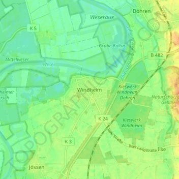
Name: Windheim topographic map, elevation, terrain.
Average elevation: 128 ft
Minimum elevation: 95 ft
Maximum elevation: 180 ft
Make a donation
Gear up for your next adventure:
As an Amazon Associate, this site earns from qualifying purchases at no extra cost to you.
Other topographic maps
Click on a map to view its topography, its elevation and its terrain.
32469
Deutschland > Nordrhein-Westfalen > Kreis Minden-Lübbecke > Petershagen > Ilse
Average elevation: 164 ft
Jössen
Deutschland > Nordrhein-Westfalen > Kreis Minden-Lübbecke > Petershagen
Average elevation: 135 ft
Gorspen-Vahlsen
Deutschland > Nordrhein-Westfalen > Kreis Minden-Lübbecke > Petershagen > Gorspen-Vahlsen
Average elevation: 144 ft
Eldagsen
Deutschland > Nordrhein-Westfalen > Kreis Minden-Lübbecke > Petershagen
Average elevation: 167 ft
Make a donation
Gear up for your next adventure:
As an Amazon Associate, this site earns from qualifying purchases at no extra cost to you.