
Make a donation
Gear up for your next adventure:
As an Amazon Associate, this site earns from qualifying purchases at no extra cost to you.
Eldagsen topographic map
Click on the map to display elevation.
Make a donation
Gear up for your next adventure:
As an Amazon Associate, this site earns from qualifying purchases at no extra cost to you.
About this map
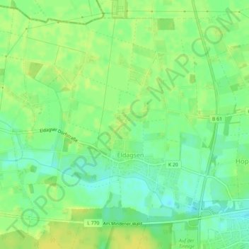
Name: Eldagsen topographic map, elevation, terrain.
Average elevation: 167 ft
Minimum elevation: 131 ft
Maximum elevation: 190 ft
Make a donation
Gear up for your next adventure:
As an Amazon Associate, this site earns from qualifying purchases at no extra cost to you.
Other topographic maps
Click on a map to view its topography, its elevation and its terrain.
Wietersheim
Deutschland > Nordrhein-Westfalen > Kreis Minden-Lübbecke > Petershagen
Average elevation: 151 ft
Bierde
Deutschland > Nordrhein-Westfalen > Kreis Minden-Lübbecke > Petershagen
Average elevation: 154 ft
Meßlingen
Deutschland > Nordrhein-Westfalen > Kreis Minden-Lübbecke > Petershagen
Average elevation: 177 ft
Seelenfeld
Deutschland > Nordrhein-Westfalen > Kreis Minden-Lübbecke > Petershagen
Average elevation: 190 ft
Make a donation
Gear up for your next adventure:
As an Amazon Associate, this site earns from qualifying purchases at no extra cost to you.
Jössen
Deutschland > Nordrhein-Westfalen > Kreis Minden-Lübbecke > Petershagen
Average elevation: 135 ft
Heue
Deutschland > Nordrhein-Westfalen > Kreis Minden-Lübbecke > Petershagen > Quetzen
Average elevation: 164 ft
Raderhorst
Deutschland > Nordrhein-Westfalen > Kreis Minden-Lübbecke > Petershagen
Die Vereine in Raderhorst haben sich zu einer Kulturgemeinschaft zusammengeschlossen. Hauptaufgabe der Kulturgemeinschaft ist die Koordinierung der Termine und die Übernahme besonderer Aufgaben. Zu den Höhepunkten eines Jahres gehören das Osterfeuer am Schützenwald und das Dorfgemeinschafts-Wochenende mit…
Average elevation: 177 ft
Ovenstädt
Deutschland > Nordrhein-Westfalen > Kreis Minden-Lübbecke > Petershagen
Average elevation: 138 ft
Make a donation
Gear up for your next adventure:
As an Amazon Associate, this site earns from qualifying purchases at no extra cost to you.
Lahde
Deutschland > Nordrhein-Westfalen > Kreis Minden-Lübbecke > Petershagen > Lahde
Average elevation: 141 ft
Windheim
Deutschland > Nordrhein-Westfalen > Kreis Minden-Lübbecke > Petershagen
Average elevation: 128 ft
Döhren
Deutschland > Nordrhein-Westfalen > Kreis Minden-Lübbecke > Petershagen
Average elevation: 144 ft
Windheim
Deutschland > Nordrhein-Westfalen > Kreis Minden-Lübbecke > Petershagen
Average elevation: 128 ft
Make a donation
Gear up for your next adventure:
As an Amazon Associate, this site earns from qualifying purchases at no extra cost to you.