Geolocate

Oaks topographic map

Click on the map to display elevation.

About this map

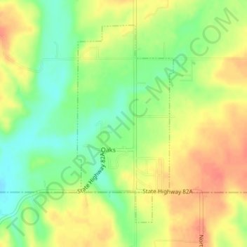
Name: Oaks topographic map, elevation, terrain.

Location: Oaks, Delaware County, Oklahoma, 74359, United States (36.15822 -94.85897 36.17983 -94.84585)

Average elevation: 1,053 ft

Minimum elevation: 968 ft

Maximum elevation: 1,129 ft

Delaware County trails, hiking, mountain biking, running and outdoor activities

Other topographic maps

Click on a map to view its topography, its elevation and its terrain.

Chloeta

United States > Oklahoma > Delaware County

Average elevation: 863 ft

Eucha

United States > Oklahoma > Delaware County

Average elevation: 1,024 ft

Kenwood

United States > Oklahoma > Delaware County

Average elevation: 866 ft

Gear up for your next adventure:

🔭Telescopic Hiking Pole - Adjustable pole for hiking stability
😴Insulated Sleeping Pads - Compact and warm pads for high-elevation camping
🚑Emergency Bivvies - Heat-reflective sleeping bags for survival situations
🛠️Outdoor Gear Repair Kit - Essential tools to fix gear on the trail
🏕️Tent Footprint - Protect your tent base from wear

As an Amazon Associate, this site earns from qualifying purchases at no extra cost to you.