
Make a donation
Gear up for your next adventure:
As an Amazon Associate, this site earns from qualifying purchases at no extra cost to you.
Kenwood topographic map
Click on the map to display elevation.
Make a donation
Gear up for your next adventure:
As an Amazon Associate, this site earns from qualifying purchases at no extra cost to you.
About this map
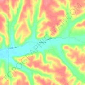
Name: Kenwood topographic map, elevation, terrain.
Location: Kenwood, Delaware County, Oklahoma, United States (36.29453 -95.00579 36.33453 -94.96579)
Average elevation: 866 ft
Minimum elevation: 719 ft
Maximum elevation: 988 ft
Delaware County trails, hiking, mountain biking, running and outdoor activities
Make a donation
Gear up for your next adventure:
As an Amazon Associate, this site earns from qualifying purchases at no extra cost to you.
Other topographic maps
Click on a map to view its topography, its elevation and its terrain.
Grand Lake o' the Cherokees
United States > Oklahoma > Delaware County > Grove
Grand Lake has a surface area of 41,779 acres (169.07 km2) of water, a storage volume of 1,515,416 acre-feet, and 1,366 miles (2,198 km) of shoreline. Unlike other lakes in Oklahoma, Grand Lake is a deep and mostly rocky lake. The average depth for Grand Lake is 36.3 feet. Its mean elevation is 745 ft (227 m)…
Average elevation: 843 ft
Make a donation
Gear up for your next adventure:
As an Amazon Associate, this site earns from qualifying purchases at no extra cost to you.
Make a donation
Gear up for your next adventure:
As an Amazon Associate, this site earns from qualifying purchases at no extra cost to you.