Geolocate

Mustang topographic map

Click on the map to display elevation.

About this map

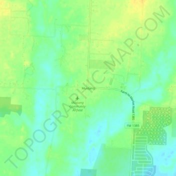
Name: Mustang topographic map, elevation, terrain.

Location: Mustang, Denton County, Texas, United States (33.30067 -96.92306 33.34067 -96.88306)

Average elevation: 597 ft

Minimum elevation: 558 ft

Maximum elevation: 636 ft

Denton County trails, hiking, mountain biking, running and outdoor activities

Other topographic maps

Click on a map to view its topography, its elevation and its terrain.

Lewisville Lake

United States > Texas > Denton County > Oak Point

Average elevation: 554 ft

Krugerville

United States > Texas > Denton County

Average elevation: 669 ft

Double Oak

United States > Texas > Denton County

Average elevation: 646 ft

Draper

United States > Texas > Denton County

Average elevation: 699 ft

Hackberry

United States > Texas > Denton County

Average elevation: 548 ft

Hebron

United States > Texas > Denton County

Average elevation: 627 ft

Hickory Creek

United States > Texas > Denton County

Average elevation: 554 ft

Cross Roads

United States > Texas > Denton County

Average elevation: 564 ft

Lakewood Village

United States > Texas > Denton County

Average elevation: 531 ft

Krum

United States > Texas > Denton County

Average elevation: 719 ft

Pilot Point

United States > Texas > Denton County

Average elevation: 650 ft

Northlake

United States > Texas > Denton County

Average elevation: 666 ft

Fort Worth

United States > Texas > Denton County

Average elevation: 699 ft

North Pointe Park

United States > Texas > Denton County > Denton

Average elevation: 689 ft

South Lakes Park

United States > Texas > Denton County > Denton

Average elevation: 659 ft

DISH

United States > Texas > Denton County

Average elevation: 659 ft

Ponder

United States > Texas > Denton County

Average elevation: 738 ft

Gear up for your next adventure:

🧴Hand Sanitizer - Keep hands clean while hiking
🧦Merino Wool Socks - Moisture-wicking, blister-preventing socks for long treks
🗺️NatGeo Topo Maps - High-quality waterproof printed topographic maps of US Parks
🎒Waterproof Dry Bags - Keep your electronics and maps dry inside your pack
Camping Coffee Makers - Enjoy premium coffee at the summit or campsite

As an Amazon Associate, this site earns from qualifying purchases at no extra cost to you.