Geolocate

Dotham topographic map

Click on the map to display elevation.

About this map

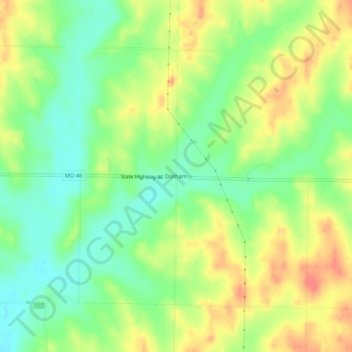
Name: Dotham topographic map, elevation, terrain.

Location: Dotham, Atchison County, Missouri, United States (40.31527 -95.25637 40.35527 -95.21637)

Average elevation: 1,014 ft

Minimum elevation: 928 ft

Maximum elevation: 1,109 ft

Atchison County trails, hiking, mountain biking, running and outdoor activities

Other topographic maps

Click on a map to view its topography, its elevation and its terrain.

Tarkio

United States > Missouri > Atchison County

Average elevation: 958 ft

Fairfax

United States > Missouri > Atchison County

Average elevation: 938 ft

Westboro

United States > Missouri > Atchison County

Average elevation: 1,033 ft

Watson

United States > Missouri > Atchison County

Average elevation: 902 ft

Nishnabotna

United States > Missouri > Atchison County

Average elevation: 961 ft

Gear up for your next adventure:

🪶Thermal Camp Blanket - Extra warmth for cold nights
GPS Sports Watch - GPS watch for running, hiking and training
🔥Plasma Lighters - Windproof lighters that work in any weather condition
🔌USB Car Charger - Car charger for on‑the‑go power needs
🌄Hiking Binoculars - Compact binoculars for scenic views and trail spotting

As an Amazon Associate, this site earns from qualifying purchases at no extra cost to you.