Geolocate

Ansonia topographic map

Click on the map to display elevation.

About this map

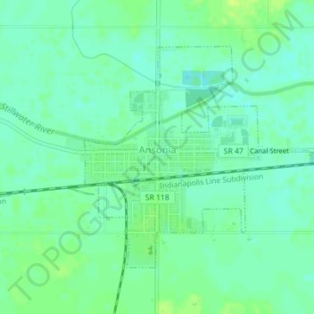
Name: Ansonia topographic map, elevation, terrain.

Location: Ansonia, Darke County, Ohio, United States (40.20437 -84.64520 40.22339 -84.61976)

Average elevation: 1,007 ft

Minimum elevation: 984 ft

Maximum elevation: 1,030 ft

Darke County trails, hiking, mountain biking, running and outdoor activities

Other topographic maps

Click on a map to view its topography, its elevation and its terrain.

Coletown

United States > Ohio > Darke County

Average elevation: 1,056 ft

Pikeville

United States > Ohio > Darke County

Average elevation: 1,020 ft

Gear up for your next adventure:

🧼Biodegradable Camping Soap - Eco‑friendly soap for outdoor hygiene
🧭Map Reading Tools - Tools and kits for map navigation
🪶Trail Camera - Capture wildlife on your hikes
👖Convertible Hiking Pants - Versatile zip-off pants for changing altitudes and temperatures
📚USA Hiking Guide Books - Top trail guides and map books

As an Amazon Associate, this site earns from qualifying purchases at no extra cost to you.