Geolocate
👉 Easily get elevation data in JSON, GeoTIFF and KML formats using Elevation API
Thank you for supporting this site ❤️
Make a donation

Coletown topographic map

Click on the map to display elevation.

About this map

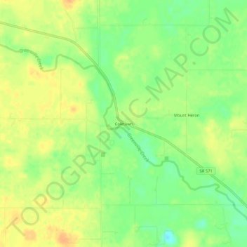
Name: Coletown topographic map, elevation, terrain.

Location: Coletown, Darke County, Ohio, United States (40.11449 -84.72274 40.15449 -84.68274)

Average elevation: 1,056 ft

Minimum elevation: 994 ft

Maximum elevation: 1,102 ft

Darke County trails, hiking, mountain biking, running and outdoor activities

Other topographic maps

Click on a map to view its topography, its elevation and its terrain.

Greenville

United States > Ohio > Darke County

Average elevation: 1,040 ft

New Weston

United States > Ohio > Darke County

Average elevation: 1,007 ft

New Madison

United States > Ohio > Darke County

Average elevation: 1,106 ft

Ansonia

United States > Ohio > Darke County

Average elevation: 1,007 ft

Pitsburg

United States > Ohio > Darke County

Average elevation: 1,024 ft

Gear up for your next adventure:

🛡️Insect Repellent - Protection against bugs during outdoor activities
📌Outdoor GPS Map App - Apps and devices for digital topographic navigation
🩳Quick‑Dry Hiking Shorts - Comfortable and quick‑dry shorts for summer hiking
🧤Tactile Hiking Gloves - Keep hands warm while operating GPS and smartphone screens
🔦LED Headlamp - Bright and durable LED headlamp for night navigation

As an Amazon Associate, this site earns from qualifying purchases at no extra cost to you.