Geolocate

Abel topographic map

Click on the map to display elevation.

About this map

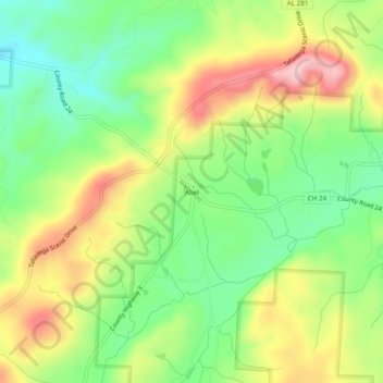
Name: Abel topographic map, elevation, terrain.

Location: Abel, Cleburne County, Alabama, United States (33.52872 -85.73246 33.56872 -85.69246)

Average elevation: 1,004 ft

Minimum elevation: 699 ft

Maximum elevation: 1,411 ft

Cleburne County trails, hiking, mountain biking, running and outdoor activities

Other topographic maps

Click on a map to view its topography, its elevation and its terrain.

Ranburne

United States > Alabama > Cleburne County

Average elevation: 994 ft

Edwardsville

United States > Alabama > Cleburne County

Average elevation: 965 ft

Heflin

United States > Alabama > Cleburne County

Average elevation: 991 ft

Fruithurst

United States > Alabama > Cleburne County

Average elevation: 1,083 ft

Gear up for your next adventure:

🥄Camping Utensil Set - Lightweight utensils for outdoor meals
🧭Outdoor Navigation Book - Learn advanced navigation skills
🥾Women's Hiking Boots - Top-rated trail boots with ankle support and superior grip
Backpacking Tents - Weight-optimized shelters for multi-day topographic surveys
💧Water Purification System - Clean water on the trail with reliable purifiers

As an Amazon Associate, this site earns from qualifying purchases at no extra cost to you.