Geolocate

Ranburne topographic map

Click on the map to display elevation.

About this map

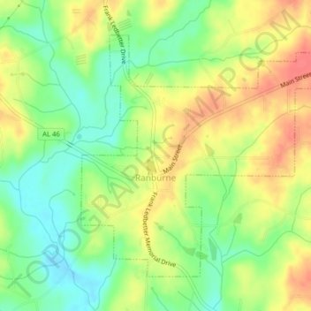
Name: Ranburne topographic map, elevation, terrain.

Location: Ranburne, Cleburne County, Alabama, United States (33.51246 -85.35409 33.53793 -85.31492)

Average elevation: 994 ft

Minimum elevation: 902 ft

Maximum elevation: 1,089 ft

Cleburne County trails, hiking, mountain biking, running and outdoor activities

Other topographic maps

Click on a map to view its topography, its elevation and its terrain.

Trickem

United States > Alabama > Cleburne County

Average elevation: 1,099 ft

Hopewell

United States > Alabama > Cleburne County

Average elevation: 1,073 ft

Liberty Hill

United States > Alabama > Cleburne County

Average elevation: 1,027 ft

Muscadine

United States > Alabama > Cleburne County

Average elevation: 1,014 ft

Abel

United States > Alabama > Cleburne County

Average elevation: 1,004 ft

Abernathy

United States > Alabama > Cleburne County

Average elevation: 971 ft

Ai

United States > Alabama > Cleburne County

Average elevation: 978 ft

Chulafinnee

United States > Alabama > Cleburne County

Average elevation: 883 ft

Micaville

United States > Alabama > Cleburne County

Average elevation: 1,181 ft

Oak Level

United States > Alabama > Cleburne County > Oak Level

Average elevation: 1,010 ft

Gear up for your next adventure:

🥤Water Filter Bottle - All‑in‑one filter bottle for safe hydration
🧭GPS Watch Accessories - Bands and chargers for GPS watches
🛠️Outdoor Gear Repair Kit - Essential tools to fix gear on the trail
🔥Fast-Boil Camping Stoves - Efficient cooking systems for quick trail meals
👟Men's Trail Runners - Lightweight footwear for fast-paced exploration and light hiking

As an Amazon Associate, this site earns from qualifying purchases at no extra cost to you.