Geolocate
👉 Easily get elevation data in JSON, GeoTIFF and KML formats using Elevation API
Thank you for supporting this site ❤️
Make a donation

Susan Moore topographic map

Click on the map to display elevation.

About this map

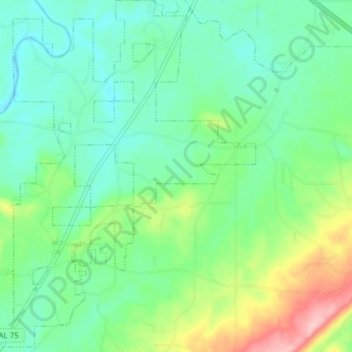
Name: Susan Moore topographic map, elevation, terrain.

Location: Susan Moore, Blount County, Alabama, United States (34.04243 -86.44378 34.10777 -86.38873)

Average elevation: 804 ft

Minimum elevation: 653 ft

Maximum elevation: 1,207 ft

Blount County trails, hiking, mountain biking, running and outdoor activities

Other topographic maps

Click on a map to view its topography, its elevation and its terrain.

Summit

United States > Alabama > Blount County

Average elevation: 853 ft

Royal

United States > Alabama > Blount County

Average elevation: 768 ft

Woodhaven

United States > Alabama > Blount County

Average elevation: 837 ft

Appalachian

United States > Alabama > Blount County

Average elevation: 1,063 ft

Appalachian

United States > Alabama > Blount County

Average elevation: 1,063 ft

Sulpher Springs

United States > Alabama > Blount County

Average elevation: 423 ft

Raccoon Mountain

United States > Alabama > Blount County

Average elevation: 1,070 ft

Appalachian

United States > Alabama > Blount County

Average elevation: 1,063 ft

Snead

United States > Alabama > Blount County

Average elevation: 781 ft

Nyota

United States > Alabama > Blount County

Average elevation: 466 ft

Gear up for your next adventure:

🧭Orienteering Set - Complete compass and map reading kit
🦶Hiking Gaiters - Keep debris and water out of your boots
🗻Climbing Gear Basics - Essential gear for beginner climbers
🥩Freeze-Dried Meals - Nutritious and lightweight food for remote expeditions
🧦Merino Wool Socks - Moisture-wicking, blister-preventing socks for long treks

As an Amazon Associate, this site earns from qualifying purchases at no extra cost to you.