Geolocate

Tennyson topographic map

Click on the map to display elevation.

About this map

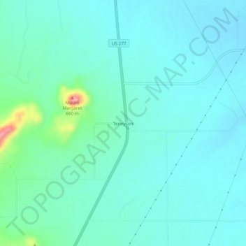
Name: Tennyson topographic map, elevation, terrain.

Location: Tennyson, Coke County, Texas, 76953, United States (31.72182 -100.30620 31.76182 -100.26620)

Average elevation: 1,873 ft

Minimum elevation: 1,804 ft

Maximum elevation: 2,224 ft

Coke County trails, hiking, mountain biking, running and outdoor activities

Other topographic maps

Click on a map to view its topography, its elevation and its terrain.

Robert Lee

United States > Texas > Coke County

Average elevation: 1,831 ft

Gear up for your next adventure:

🧷Carabiner Set - Durable clips for gear attachment
🔥Camping Stove - Portable stove for camping and backcountry cooking
🦺Reflective Outdoor Gear - Safety gear for low‑light conditions
🪶Fire Starter Kit - Reliable fire starter for survival and camping
🚁Photography Drones - Capture stunning aerial views of landforms and topography

As an Amazon Associate, this site earns from qualifying purchases at no extra cost to you.