
Robert Lee topographic map
Click on the map to display elevation.
About this map
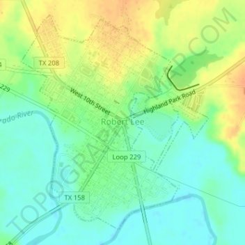
Name: Robert Lee topographic map, elevation, terrain.
Location: Robert Lee, Coke County, Texas, United States (31.88332 -100.49632 31.90702 -100.47194)
Average elevation: 1,831 ft
Minimum elevation: 1,781 ft
Maximum elevation: 1,896 ft
Coke County trails, hiking, mountain biking, running and outdoor activities
Other topographic maps
Click on a map to view its topography, its elevation and its terrain.