Geolocate

Paraghate topographic map

Click on the map to display elevation.

About this map

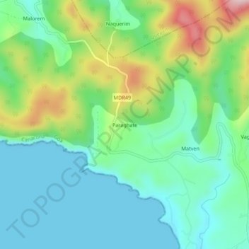
Name: Paraghate topographic map, elevation, terrain.

Location: Paraghate, Canacona, South Goa District, Goa, 503702, India (15.05832 73.94108 15.09832 73.98108)

Average elevation: 308 ft

Minimum elevation: 0 ft

Maximum elevation: 1,073 ft

Other topographic maps

Click on a map to view its topography, its elevation and its terrain.

Cola Beach

India > Goa > Canacona

Average elevation: 79 ft

Galgibaga

India > Goa > Canacona > Poingonin

Average elevation: 148 ft

Cola Beach

India > Goa > Canacona

Average elevation: 79 ft

Talpona

India > Goa > Canacona > Canacona

Average elevation: 509 ft

Butterfly Beach

India > Goa > Canacona

Average elevation: 92 ft

Gear up for your next adventure:

🧣Hiking Neck Gaiter - Multi‑use neck protection for outdoor weather
🧦Merino Wool Socks - Moisture-wicking, blister-preventing socks for long treks
🛏️Cold Weather Sleeping Bag - Warm sleeping bag for cold conditions
🪶Multi‑Purpose Knife - Useful blade for camp and trail
🧺Microfiber Travel Towels - Compact and fast-drying towels for trail use

As an Amazon Associate, this site earns from qualifying purchases at no extra cost to you.