Geolocate

Cola Beach topographic map

Click on the map to display elevation.

About this map

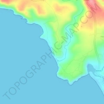
Name: Cola Beach topographic map, elevation, terrain.

Location: Cola Beach, Canacona, South Goa, Goa, India (15.05591 73.96800 15.06250 73.97190)

Average elevation: 79 ft

Minimum elevation: -3 ft

Maximum elevation: 351 ft

Other topographic maps

Click on a map to view its topography, its elevation and its terrain.

Kolamb

India > Goa > Canacona

Average elevation: 52 ft

Canacona

India > Goa > Canacona

Canacona is located at 15°01′N 74°01′E / 15.02°N 74.02°E / 15.02; 74.02. It has an average elevation of 10 metres (32 feet). Canacona is the southernmost taluka of Goa.

Average elevation: 194 ft

Ponsulem

India > Goa > Canacona > Canacona

Average elevation: 75 ft

Cabo de Rama

India > Goa > Canacona > Kuddi > Cabo de Rama

Average elevation: 56 ft

Kajumole

India > Goa > Canacona > Parven

Average elevation: 164 ft

Gaondongrim

India > Goa > Canacona

Average elevation: 351 ft

Paraghate

India > Goa > Canacona

Average elevation: 308 ft

Turtle rock

India > Goa > Canacona > Parven > Betul

Average elevation: 59 ft

Kolsar

India > Goa > Canacona > Talpona

Average elevation: 49 ft

Patnam

India > Goa > Canacona > Rajbag

Average elevation: 49 ft

Betul

India > Goa > Canacona > Parven

Average elevation: 121 ft

Gear up for your next adventure:

🪑Ultralight Camp Chairs - Portable seating for resting after a long day of mapping
🏥Hiking First Aid Kits - Comprehensive medical kits for remote trail injuries
🧤Hiking Gloves - Protective gloves for rugged trails
🏕️Tent Footprint - Protect your tent base from wear
🎒Trekking Poles - Sturdy poles for balance and stability on rough terrain

As an Amazon Associate, this site earns from qualifying purchases at no extra cost to you.