
Make a donation
Gear up for your next adventure:
As an Amazon Associate, this site earns from qualifying purchases at no extra cost to you.
Reno Beach topographic map
Click on the map to display elevation.
Make a donation
Gear up for your next adventure:
As an Amazon Associate, this site earns from qualifying purchases at no extra cost to you.
About this map
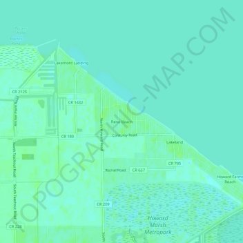
Name: Reno Beach topographic map, elevation, terrain.
Location: Reno Beach, Lucas County, Ohio, United States (41.64338 -83.28937 41.68338 -83.24937)
Average elevation: 568 ft
Minimum elevation: 554 ft
Maximum elevation: 587 ft
Lucas County trails, hiking, mountain biking, running and outdoor activities
Make a donation
Gear up for your next adventure:
As an Amazon Associate, this site earns from qualifying purchases at no extra cost to you.
Other topographic maps
Click on a map to view its topography, its elevation and its terrain.
Oregon
United States > Ohio > Lucas County
Perhaps the most well-known attraction in Oregon is the Sundance Drive-In, one of the last in the region. Pearson Metropark, within the city limits, and Maumee Bay State Park, have preserved or re-created sections of the original Black Swamp topography and forest. The state park also offers a waterfront resort…
Average elevation: 597 ft