
Make a donation
Gear up for your next adventure:
As an Amazon Associate, this site earns from qualifying purchases at no extra cost to you.
Arhuay topographic map
Click on the map to display elevation.
Make a donation
Gear up for your next adventure:
As an Amazon Associate, this site earns from qualifying purchases at no extra cost to you.
About this map
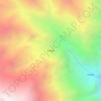
Name: Arhuay topographic map, elevation, terrain.
Location: Arhuay, Choco, Castilla, Arequipa, Perú (-15.58305 -72.17562 -15.54305 -72.13562)
Average elevation: 12,552 ft
Minimum elevation: 8,491 ft
Maximum elevation: 16,165 ft
Make a donation
Gear up for your next adventure:
As an Amazon Associate, this site earns from qualifying purchases at no extra cost to you.
Other topographic maps
Click on a map to view its topography, its elevation and its terrain.
Valle del Colca
Perú > Arequipa > Choco > Soro
El Altiplano en el Colca está representado por una extensa meseta que se desarrolla a altitudes entre 4000 y 4500 m s. n. m.. Ésta es una superficie casi llana o suavemente ondulada, sobre la cual destacan cerros y volcanes que sobrepasan los 5000 m s. n. m.. Es en estas superficies donde sobresalen volcanes…
Average elevation: 10,397 ft