Geolocate

Trenton topographic map

Click on the map to display elevation.

About this map

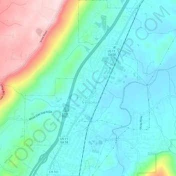
Name: Trenton topographic map, elevation, terrain.

Location: Trenton, Dade County, Georgia, United States (34.85374 -85.52850 34.89734 -85.49415)

Average elevation: 919 ft

Minimum elevation: 673 ft

Maximum elevation: 1,667 ft

Dade County trails, hiking, mountain biking, running and outdoor activities

Other topographic maps

Click on a map to view its topography, its elevation and its terrain.

Head River

United States > Georgia > Dade County

Average elevation: 1,919 ft

West Brow

United States > Georgia > Dade County

Average elevation: 1,398 ft

New England

United States > Georgia > Dade County

Average elevation: 843 ft

Wildwood

United States > Georgia > Dade County

Average elevation: 846 ft

Cole City

United States > Georgia > Dade County

Average elevation: 1,414 ft

Trenton

United States > Georgia > Dade County

Average elevation: 919 ft

Gear up for your next adventure:

🧺Microfiber Travel Towels - Compact and fast-drying towels for trail use
🌄Hiking Binoculars - Compact binoculars for scenic views and trail spotting
🎒Outdoor Daypacks - Lightweight backpacks designed for carrying maps and essential gear
🏕️Family Camping Gear - Essentials for group camping trips
📌Outdoor GPS Map App - Apps and devices for digital topographic navigation

As an Amazon Associate, this site earns from qualifying purchases at no extra cost to you.