Geolocate

Cole City topographic map

Click on the map to display elevation.

About this map

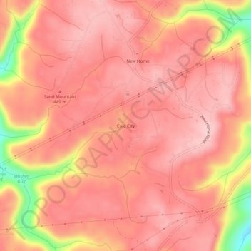
Name: Cole City topographic map, elevation, terrain.

Location: Cole City, Dade County, Georgia, United States (34.92492 -85.55467 34.96492 -85.51467)

Average elevation: 1,414 ft

Minimum elevation: 902 ft

Maximum elevation: 1,585 ft

Dade County trails, hiking, mountain biking, running and outdoor activities

Other topographic maps

Click on a map to view its topography, its elevation and its terrain.

Trenton

United States > Georgia > Dade County

Average elevation: 919 ft

New England

United States > Georgia > Dade County

Average elevation: 794 ft

Trenton

United States > Georgia > Dade County

Average elevation: 919 ft

Cole City

United States > Georgia > Dade County

Average elevation: 1,368 ft

Gear up for your next adventure:

📚Navigation Handbooks - Master the art of reading topographic maps and using a compass
📶Vehicle Signal Boosters - Improve reception in rural areas while driving to trailheads
🥾Hiking Shoes - Durable and comfortable shoes for trail hiking
👟Men's Trail Runners - Lightweight footwear for fast-paced exploration and light hiking
🌡️Portable Weather Meter - Track weather conditions on the trail

As an Amazon Associate, this site earns from qualifying purchases at no extra cost to you.