Geolocate

Killen topographic map

Click on the map to display elevation.

About this map

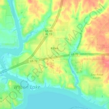
Name: Killen topographic map, elevation, terrain.

Location: Killen, Lauderdale County, Alabama, United States (34.84983 -87.56162 34.86936 -87.49243)

Average elevation: 594 ft

Minimum elevation: 509 ft

Maximum elevation: 722 ft

Lauderdale County trails, hiking, mountain biking, running and outdoor activities

Other topographic maps

Click on a map to view its topography, its elevation and its terrain.

Killen

United States > Alabama > Lauderdale County

Average elevation: 594 ft

Creekwood

United States > Alabama > Lauderdale County > Florence

Average elevation: 591 ft

Rogersville

United States > Alabama > Lauderdale County

Average elevation: 646 ft

Gear up for your next adventure:

🧭Pro Hiking Compasses - High-accuracy liquid-filled compasses for topographic orientation
🏕️Tent Footprint - Protect your tent base from wear
🪶Wildlife Field Guides - Learn animal tracking and species ID
📱Heavy-Duty Phone Cases - Drop-proof and waterproof protection for outdoor navigation
😴Insulated Sleeping Pads - Compact and warm pads for high-elevation camping

As an Amazon Associate, this site earns from qualifying purchases at no extra cost to you.