Geolocate

Killen topographic map

Click on the map to display elevation.

About this map

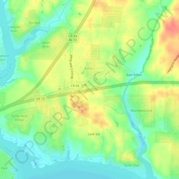
Name: Killen topographic map, elevation, terrain.

Location: Killen, Lauderdale County, Alabama, United States (34.84804 -87.55397 34.86834 -87.50586)

Average elevation: 594 ft

Minimum elevation: 509 ft

Maximum elevation: 699 ft

Other topographic maps

Click on a map to view its topography, its elevation and its terrain.

Florence

United States > Alabama > Lauderdale County

Average elevation: 571 ft

Florence

United States > Alabama > Lauderdale County

Average elevation: 568 ft

Rogersville

United States > Alabama > Lauderdale County

Average elevation: 646 ft

Killen

United States > Alabama > Lauderdale County

Average elevation: 594 ft

Lexington

United States > Alabama > Lauderdale County

Average elevation: 741 ft

Rogersville

United States > Alabama > Lauderdale County

Average elevation: 646 ft

Florence

United States > Alabama > Lauderdale County

Average elevation: 568 ft

Gear up for your next adventure:

📻Weather Alert Radios - Stay informed of storm risks while off-the-grid
📡GPS Antenna Upgrade - Enhance GPS reception in remote terrain
🗺️Topographic Maps - Detailed topo maps for hiking, exploring and outdoor navigation
🔦Powerful Headlamps - Ultra-bright hands-free lighting for night navigation
Solar GPS Watches - Advanced multisport watches with built-in topographic maps

As an Amazon Associate, this site earns from qualifying purchases at no extra cost to you.