
Make a donation
Gear up for your next adventure:
As an Amazon Associate, this site earns from qualifying purchases at no extra cost to you.
Wachtendonk topographic map
Click on the map to display elevation.
Make a donation
Gear up for your next adventure:
As an Amazon Associate, this site earns from qualifying purchases at no extra cost to you.
About this map
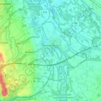
Name: Wachtendonk topographic map, elevation, terrain.
Average elevation: 118 ft
Minimum elevation: 82 ft
Maximum elevation: 262 ft
Make a donation
Gear up for your next adventure:
As an Amazon Associate, this site earns from qualifying purchases at no extra cost to you.
Other topographic maps
Click on a map to view its topography, its elevation and its terrain.
Make a donation
Gear up for your next adventure:
As an Amazon Associate, this site earns from qualifying purchases at no extra cost to you.
Make a donation
Gear up for your next adventure:
As an Amazon Associate, this site earns from qualifying purchases at no extra cost to you.
Pfalzdorf
Deutschland > Nordrhein-Westfalen > Kreis Kleve > Goch
Pfalzdorf liegt links des Rheins im niederrheinischen Tiefland zwischen Goch, Kalkar und Kleve auf den Pfalzdorfer Höhen, einem Teil des Niederrheinischen Höhenzugs. Benachbarte Orte sind Bedburg-Hau im Norden, Louisendorf im Nordosten, Keppeln im Osten, Goch im Süden, Asperden im Südwesten und Nierswalde…
Average elevation: 82 ft
Make a donation
Gear up for your next adventure:
As an Amazon Associate, this site earns from qualifying purchases at no extra cost to you.
Make a donation
Gear up for your next adventure:
As an Amazon Associate, this site earns from qualifying purchases at no extra cost to you.
Make a donation
Gear up for your next adventure:
As an Amazon Associate, this site earns from qualifying purchases at no extra cost to you.
Ferienpark Kevelaer
Deutschland > Nordrhein-Westfalen > Kreis Kleve > Kevelaer > Schravelnsche Heide
Average elevation: 69 ft
Make a donation
Gear up for your next adventure:
As an Amazon Associate, this site earns from qualifying purchases at no extra cost to you.
Make a donation
Gear up for your next adventure:
As an Amazon Associate, this site earns from qualifying purchases at no extra cost to you.
Make a donation
Gear up for your next adventure:
As an Amazon Associate, this site earns from qualifying purchases at no extra cost to you.
Make a donation
Gear up for your next adventure:
As an Amazon Associate, this site earns from qualifying purchases at no extra cost to you.
Gieselberg
Deutschland > Nordrhein-Westfalen > Kreis Kleve > Straelen > Auwel > Bormig
Average elevation: 115 ft
Make a donation
Gear up for your next adventure:
As an Amazon Associate, this site earns from qualifying purchases at no extra cost to you.
Pfalzdorf
Deutschland > Nordrhein-Westfalen > Kreis Kleve > Goch
Pfalzdorf liegt links des Rheins im niederrheinischen Tiefland zwischen Goch, Kalkar und Kleve auf den Pfalzdorfer Höhen, einem Teil des Niederrheinischen Höhenzugs. Benachbarte Orte sind Bedburg-Hau im Norden, Louisendorf im Nordosten, Keppeln im Osten, Goch im Süden, Asperden im Südwesten und Nierswalde…
Average elevation: 82 ft
Make a donation
Gear up for your next adventure:
As an Amazon Associate, this site earns from qualifying purchases at no extra cost to you.